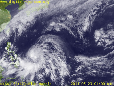
At 5pm today, Tropical Storm CHEDENG accelerated and intensified further and is now moving WNW at 19 kph closer to the Visayas Region. The center of CHEDENG is about 815 km East of Borongan, Samar with wind gusts of up to 140 kph. CHEDENG shall continue to intensify and move further WNW along the warm waters of the Philippine Sea. At 2am tomorrow – 24 May, it shall be 645 km East of Dolores, Samar. On 24 May at 2pm, CHEDENG is forecast to be 490 km East of Dolores, Samar.
***
25 May(2pm) forecast shows CHEDENG to be about
255 km ENE of Gubat, Sorsogon
260 km ENE of Legaspi City
265 km ENE of Virac, Catanduanes
425 km ENE of Naga City/CWC
During this time, CHEDENG's wind gusts shall intensify to 230 kph.
***
26 May(2pm) reveals CHEDENG to be
280 km NNE of Virac, Catanduanes
200 km NNE of Caramoan, Camarines Sur
290 km NNE of Daet, Camarines Norte
295 km ESE of Ilagan, Isabela
During this time, CHEDENG's wind gusts shall intensify to 250 kph.
***
On 27 May(2pm), the system is estimated to be
100 km ESE of Babuyan Island
170 km SE of Basco, Batanes
During this time, CHEDENG's wind gusts shall intensify to 260 kph.
***
Long range forecast on 28 May(2pm) reveals CHEDENG to be
325 km NE of Basco, Batanes (now outside PAR)
180 km East of Chenggong, Taiwan
During this time, CHEDENG's wind gusts shall intensify to 260 kph.
***
Starting today until 27 May, CHEDENG is expected to intensify further to TYPHOON and even SUPER TYPHOON Status with projected wind gusts of 260 km/hr.
***
FORECAST ANALYSIS AND EFFECTS:
Based on this latest forecast from JTWC and ECMWF, the system is still showing a sharp northerly turn in the later part of the extended forecast period approaching closely to the Batanes Group of Islands sometime in the morning or afternoon of 27 May trekking also closely to Santa Ana and Palaui Island in Cagayan Province.
Forecast models are still in fair agreement with their respective datas showing SONGDA/CHEDENG gliding to the northeast of Northern Visayas and the Bicol Region. Landfall in any part of the Philippines is still remote as of this forecast. At any rate, we shall be monitoring closely the progress of this weather system for sudden changes throughout the forecast period. It is also noted that the rapid intensification of this system can be attributed to the fact that it is lingering in the open warm waters of the Pacific Ocean.
The system is expected to enhance the southwest moonsoon once it hovers to the NE of Visayas and the Bicol region. Expect rains that could trigger flashfloods and winds sometime from 25 to 27 May. Strong to gale force winds are expected to affect the Eastern seaboards of Visayas and Mindanao.
Expect rough to very rough sea conditions along these areas. FISHING BOATS AND OTHER SMALL SEACRAFTS ARE ADVISED NOT TO VENTURE OUT INTO THE SEA WHILE LARGER SEA VESSELS ARE ALERTED AGAINST BIG WAVES.
CHEDENG shall be out of the country between 1am and 3am of 28 May. It is expected to recurve to the northeast towards Okinawa and Western Honshu, Japan. Stay tuned for more updates.
P.S.
CHEDENG(Songda) is a very strong and dangerous storm. If this hits land, it would be a deadly catastrophe. The public and the disaster coordinating councils concerned are advised to take appropriate actions and precautionary measures.
TRACKING MAP OF TROPICAL STORM CHEDENG(Songda)
LATEST SATELLITE IMAGE as of 23 May (2pm)


No comments:
Post a Comment