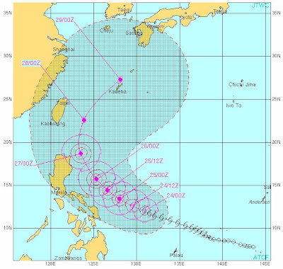
At 11am today, Tropical Storm CHEDENG drifted slowly WNW at 13 kph closer to the Visayas and Bicol Region. The center of CHEDENG is about 720 km ESE of Sorsogon with wind gusts of up to 130 kph. CHEDENG is expected to intensify as it moves WNW along the warm waters of the Philippine Sea and closer to Eastern Luzon.
At 8pm tonight – 24 May, it shall be 600 km ESE of Sorsogon. On 25 May at 8am, CHEDENG is forecast to be 410 km ESE of Virac, Catanduanes/510 km East of Naga City/CWC or 720 km ESE of Manila/Quezon City.
***
26 May(8am) forecast shows CHEDENG to be about
260 km NE of Virac, Catanduanes
315 km NE of Naga City/CWC
370 km ESE of Ilagan, Isabela
During this time, CHEDENG's wind gusts shall intensify to 210 kph.
***
27 May(8am) reveals CHEDENG to be
145 km ENE of Sta. Ana, Cagayan
185 km ESE of Babuyan Island
250 km SE of Basco, Batanes
During this time, CHEDENG's wind gusts shall intensify to 250 kph.
***
On 28 May(8am), the system is estimated to be
305 km NE of Basco, Batanes
During this time, CHEDENG's wind gusts shall intensify to 260 kph.
***
Long range forecast on 29 May(8am) reveals CHEDENG to be
110 km NE of Kadena Base Okinawa, Japan (now out of the PAR)
During this time, CHEDENG's wind gusts shall weaken to 240 kph.
***
CHEDENG is expected to intensify further to TYPHOON or Near Super Typhoon Strength during the forecast period with projected wind gusts of 260 km/hr.
***
AREAS Having Public Storm Warning Signal (Click the image to enlarge)
FORECAST ANALYSIS AND EFFECTS:
Based on this latest forecast from JTWC, the system shows a sharp turn to the north and a northeastern recurvature in the later part of the extended forecast period approaching very close to Basco, Batanes sometime on 27 May or early morning of 28 May, trekking also closely at Santa Ana, Palaui Island and Northern Cagayan Province. Expect stormy weather in these areas beginning 27 May.
Forecast models still shows SONGDA/CHEDENG gliding to the northeast of Northern Visayas and the Bicol Region. However, ECMWF now shows a more westerly track in the medium range forecast bringing CHEDENG's circulation closer to Northern Visayas and the Bicol region (26 May) and the rest of the eastern section of Luzon including Metro Manila (27 May). ECMWF also shows a direct Cagayan and Batanes Group of Islands landfall on 28 May. CHEDENG is also expected to accelerate later in the forecast between 26 to 29 May.
Overall, Landfall is still 50% possible along the northern coast of extreme Northern Luzon and 30% possible along the Bicol region as of this forecast.
The system is expected to enhance the southwest moonsoon once it hovers to the NE of Visayas, the Bicol region and the rest of Eastern Luzon. The rainbands of CHEDENG shall affect Northern Visayas, Northern Bicol, Isabela, Cagayan and the Batanes Group of Islands when this system approaches. Expect rains in LUZON and VISAYAS that could trigger flashfloods and winds sometime from 25 to 27 May. Strong to gale force winds (55 kph or higher) are expected to affect the Eastern seaboards of Luzon, Visayas and Mindanao becoming stronger in extreme Northern Luzon beginning 27 May.
Expect rough to very rough sea conditions along these areas. FISHING BOATS AND OTHER SMALL SEACRAFTS ARE ADVISED NOT TO VENTURE OUT INTO THE SEA WHILE LARGER SEA VESSELS ARE ALERTED AGAINST BIG WAVES.
CHEDENG shall be out of the country in the morning of 29 May. It is expected to recurve to the northeast missing Taiwan and shall head towards Okinawa and Western Honshu, Japan. Stay tuned for more updates.
P.S.
CHEDENG(Songda) is a very strong and dangerous storm. If this hits land, it would be a deadly catastrophe. The public and the disaster coordinating councils concerned are advised to take appropriate actions and precautionary measures.
TRACKING MAP OF TROPICAL STORM CHEDENG(Songda)
Latest Satellite Image (24 May at 8am)


No comments:
Post a Comment