
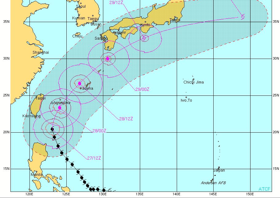
At 8am tomorrow – 28 May, it shall be 380 km NE of Basco, Batanes or 320 km ESE of Taipei, Taiwan with wind gusts dropping to 260 kph.
On 28 May at 8pm, CHEDENG is forecast to be 100 km WNW of Okinawa, Japan or outside the Northern Philippine Area of Responsibility. Wind gusts drops further to 210 kph.
***
2-Day SUPER TYPHOON CHEDENG(Songda) Forecast Positions
***
AREAS HAVING PUBLIC STORM SIGNAL WARNING
STORM SIGNAL # 3:Batanes Group of Islands
STORM SIGNAL # 2:
Babuyan Group of Islands
STORM SIGNAL # 1:
Apayao
Cagayan
***
FORECAST ANALYSIS AND EFFECTS:
Cooler sea surface temperature and increased vertical wind shear shall weaken the system rapidly as it tracks out of the PAR and into Okinawa, Japan. CHEDENG shall be out of the country by 28 May. Extra tropical transition is also expected beginning 30 May. It is shall to recurve to the northeast missing Taiwan.
Chedeng shall be in the vicinity of Okinawa sometime during the night of 28 May and shall move northeast towards the Ryukyu Islands at midnight or early morning of 29 May. Expect stormy weather in these areas over the weekend.
Expect rough to very rough sea conditions along these areas. FISHING BOATS AND OTHER SMALL SEACRAFTS ARE ADVISED NOT TO VENTURE OUT INTO THE SEA WHILE LARGER SEA VESSELS ARE ALERTED AGAINST BIG WAVES.
In the Bicol region, the rest of Visayas and Mindanao, improving weather condition is expected as Super Typhoon CHEDENG continues to move away.
Forecast models are still in excellent agreement with a NO LANDFALL Scenario in the Philippines for Typhoon SONGDA/CHEDENG. However, different results in the extended forecast (30 May) were generated with some models bringing CHEDENG over Japan while other models favoring an open water scenario just South of Japan. CHEDENG shall continue to accelerate later in the forecast and eventually lose strength.
P.S.
CHEDENG(Songda) is a strong and dangerous storm. If this hits land, it would be a deadly catastrophe. The public and the disaster coordinating councils concerned are advised to take appropriate actions and precautionary measures.
TRACKING MAP OF TYPHOON CHEDENG(Songda)
SATELLITE IMAGE as of 27 May @ 11pm

No comments:
Post a Comment