
At 2pm today – 26 May, it shall be 240 km ENE of Naga City/CWC and 455 km ESE of Palanan, Isabela. Its wind gusts shall intensify to 270 kph.
On 27 May at 2am, CHEDENG is forecast to be 295 km ESE of Palanan, Isabela or 500 km SE of Basco, Batanes. Wind gusts shall intensify further to 275 kph.
***
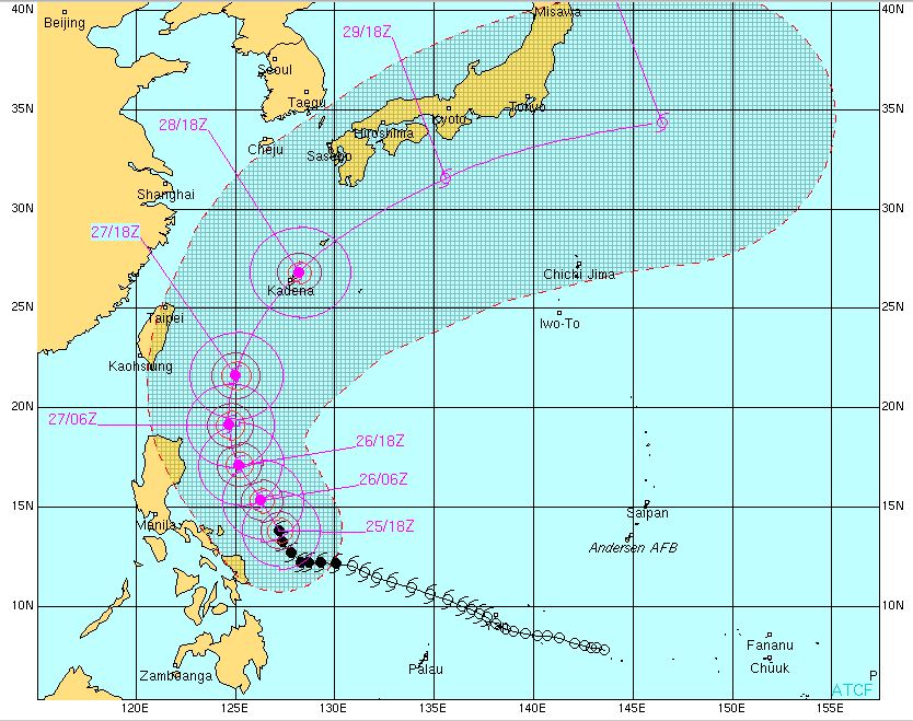
4-Day TYPHOON CHEDENG(Songda) Forecast Positions
***
AREAS HAVING PUBLIC STORM SIGNAL WARNING

FORECAST ANALYSIS AND EFFECTS:
The system started to turn more to the north (poleward) over the past 6 hours decreasing its threat to the Bicol Region as the High Pressure Ridge extending in Japan weakens. CHEDENG shall continue to crawl NW to NNW along the Philippine Sea and intensify. CHEDENG is a few hundred kilometers to the Northeast of Catanduanes. Deteriorating weather is now being experienced in Samar, Leyte, Bicol including Northern Mindanao and becoming widespread in Central Visayas as the Southwest Moonsoon shall begin to be enhanced by this typhoon. CHEDENG shall remain in the open waters of the Philippines throughout the forecast and shall continue moving NW towards the northern portion of the Philippine Sea. A sharp turn to the north and a northeastern recurvature in the later part of the extended forecast period is expected gliding hundreds of kilometers to the east of Isabela and Batanes Group of Islands sometime on 27 May or early morning of 28 May.
Forecast models are in excellent agreement with a NO LANDFALL Scenario for Typhoon SONGDA/CHEDENG. CHEDENG is also expected to accelerate later in the forecast between 27 to 31 May.
The system is now enhancing the southwest moonsoon while lingering to the NE of the Bicol region. The rainbands of CHEDENG continues to affect Northern Visayas, and Bicol. Expect rains in LUZON and VISAYAS that could trigger flashfloods and winds sometime from 26 and 27 May. Strong to gale force winds (55 kph or higher) are expected to affect the Eastern seaboards of Luzon, Visayas and Mindanao becoming stronger in extreme Northern Luzon beginning 27 May.
Expect rough to very rough sea conditions along these areas. FISHING BOATS AND OTHER SMALL SEACRAFTS ARE ADVISED NOT TO VENTURE OUT INTO THE SEA WHILE LARGER SEA VESSELS ARE ALERTED AGAINST BIG WAVES.
CHEDENG has now intensified into TYPHOON Strength with projected wind gusts of up to 275 km/hr. However, low ocean heat content in the later part of the forecast shall weaken the system as it tracks out of the PAR. Extra tropical transition is also expected afterwards.
CHEDENG shall be out of the country by 28 or early morning of 29 May. It is expected to recurve to the northeast missing Taiwan as an extra tropical storm system. Stay tuned for more updates.
P.S.
CHEDENG(Songda) is a strong and dangerous storm. If this hits land, it would be a deadly catastrophe. The public and the disaster coordinating councils concerned are advised to take appropriate actions and precautionary measures.
TRACKING MAP OF TYPHOON CHEDENG(Songda)
SATELLITE IMAGE as of 26 May @ 5am reveals CHEDENG's eye!

No comments:
Post a Comment